Sustainable urban development
Geospatial solutions for livable and vibrant cities and regions.
Over the last decades, demographic and economic changes have propelled cities and urban centers to become the principal habitat of humankind. This trend is going to even increase in years to come and cities and urbanized areas are now on the front line of the management of rapid changes and play a leading role in the global sustainable development agenda. It is only through cities that global challenges in poverty reduction, social cohesion, sustainable economic growth, environmental responsiveness and climate change adaptation may be addressed adequately.
Our geospatial solutions support urban practitioners both on a strategic and operational level in the complex process of the city assets optimization balancing a resilient, adaptable, environmentally responsible, inclusive and economically vibrant city. We assist in responding effectively to these societal challenges and provide actionable intelligence supporting sustainability and operational efficiency whilst substantially reducing the cost of monitoring urban changes and environmental risks.
Land Assets Monitoring
Urban planning information is historically very heterogeneous, making it challenging to feed into standard processes for project preparatory, design, implementation, monitoring or communication activities, requiring local data adaptation on a case-by-case basis. Our solutions provide a valuable source of standard, harmonized data to keep these adaptation costs low. Up-to-date information on land use and land cover assets quantity, availability, structure and distribution allows the evaluation of the ongoing land changes and their impact on city or region development potential. All this available on a long temporal scale provides actionable information for operational land assets management and improvement prioritization for city managers and private businesses.
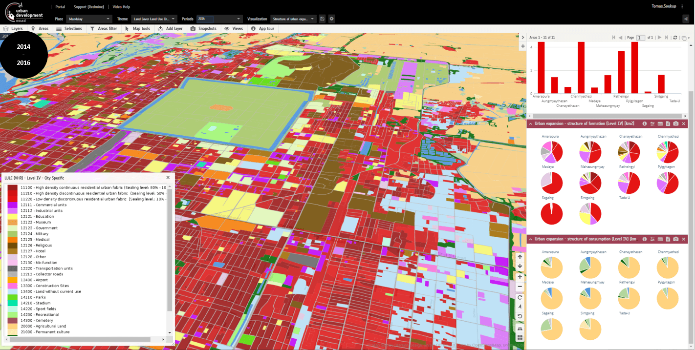
Land Assets Monitoring example from application for Mandalay, Myanmar as presented on VISAT Exploration platform. ©GISAT
Urban Expansion
Projected massive urban expansion trends require significant actions to affect future growth trajectories to minimize its impact on global biodiversity and vegetation carbon losses. Our solutions help to monitor their sustainable basis by supporting planning their future locations and magnitudes. Overall dynamic and major urbanisation processes like an extension (sprawling), densification or land recycling can be identified in rich spatial-temporal context quickly and accurately. Mastering urban expansion prevents overexploiting of environmental resources and increases the urban population's quality of life and safety.
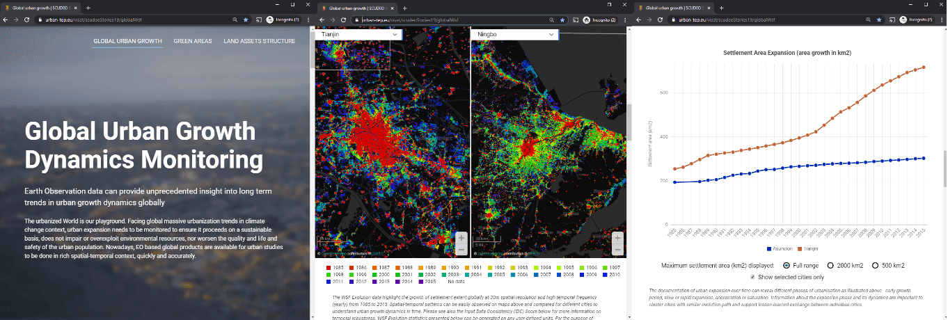
Long term urban expansion analysis based on World Settlement Footprint Evolution data. ©GISAT, WSF Evolution data ©DLR
Promoting Green and livable cities
Green areas and public spaces are recognized as significant factors contributing to the overall livability of the city. Green infrastructure is a crucial driver of nature-based solutions in cities. Our solutions provide a range of tailored indicators to describe the quantity, quality and distribution of public spaces (urban green areas, public areas and street space) in the city, including their evolution over time. Our solutions offer a systematic and contextualized city-wide understanding of urban green and public spaces in place and their improvement potential. It significantly contributes to the related green and livable cities planning and upgrading activities. Green (and blue) infrastructure provides also a base for cooling and absorbing capacity to improve city resilience to climate impacts, often resulting also in other environmental, economic, and social co-benefits.
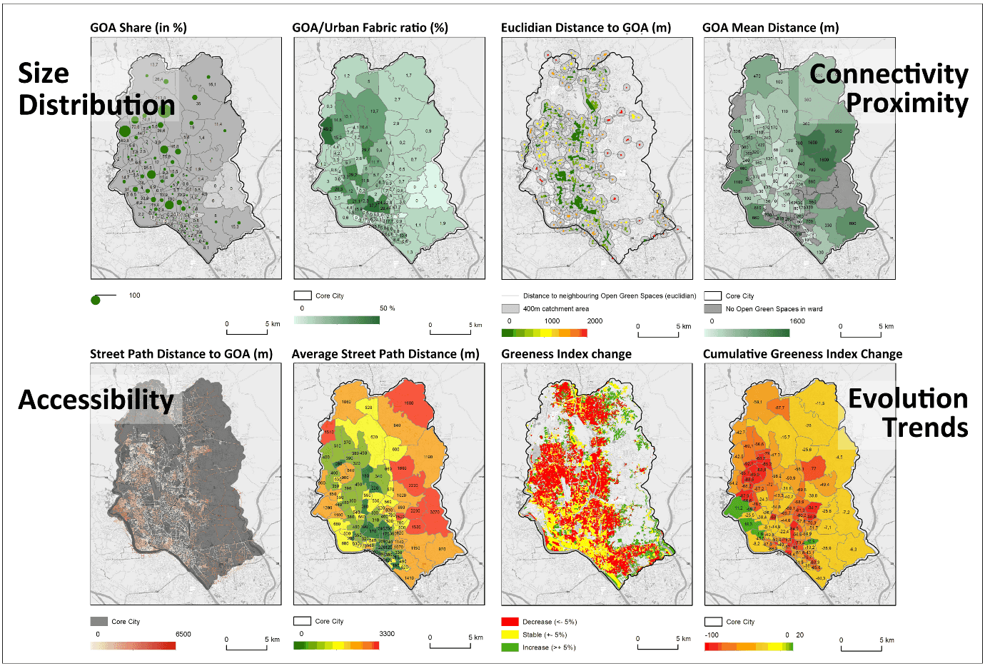
GreenMonitor - AI supported EO workflow for green and open areas monitoring. Example: Green and Open Areas monitoring and analytics in Dhaka, Pakistan. ©GISAT
Slum upgrading and poverty reduction
In many cities worldwide slum areas and slum populations are on growth. Uncontrolled expansion of urban areas undermines the efficiencies of compact urban living and marginalizes low-income populations in peripheral parts of cities, often in dense informal settlements - subject to substandard housing quality, impaired accessibility and insufficient provision of basic services. Our solutions support authorities addressing the specific needs and challenges related to slum management. Up-to-date identification, delineation and characterization of slums at the city scale helps in better slum upgrade planning and prioritization of interventions for poverty reduction.
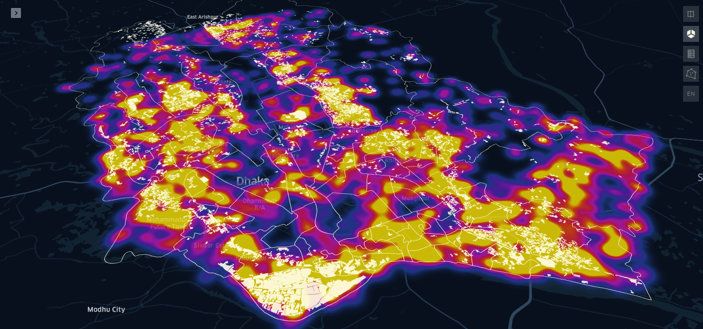
SlumDetector - AI supported EO workflow for slum monitoring. Example: Slum heatmap for Dhaka, Pakistan. ©GISAT
Urban Climate Resilience – Nature Based Solutions
Sustainable city planning requires hazards to be mitigated where they can be anticipated, and specifically urban structures must be managed to avoid the consequences of climate change. These require consistent and up-to-date identification of related risks due to flooding, subsidence or other natural or man-made factors and avoidance of urban development in risk zones. Our solutions help identify locations prone to hazards and to evaluate associated risks. They provide actionable intelligence supporting all phases of risk and disaster management cycle, reducing the cost of monitoring as well as potential harmful impact to urban assets and population. At the same time, the potential to deploy more nature-based approaches as prevention or mitigation measures can be supported too. Nature based solutions (NBS) provides multi-functional and cost-effective way to increase city risk resilience, at the same time reducing heat waves, pollution and energy costs and improving public health by regenerating urban spaces.
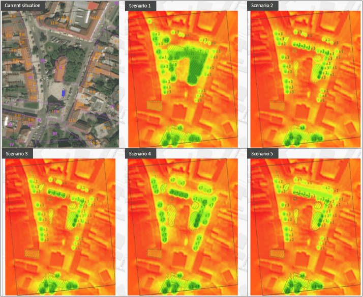
Nature Based Solution support example: Urban Heat Island analysis for various green scenarios for urban designs of Masaryk Square, Hodonin, Czech Republic. ©GISAT and VITO
